Virtual cities can let us experience the difference between a suburban emphasis on life in America versus an urban emphasis. Let's walk about in the virtual and see which life we prefer more. Sure James includes some slides on how to retrofit our suburban wastelands into places we'd like to spend time in, but the transition is not as obvious as it could be with a virtual city platform, eh?
Monday, June 11, 2007
That's What I am Talking About
There is no doubt that we have over-reacted to the filth of industrialization that plagued our cities early in the industrial age. The information age has let us stay in suburbia and remain connected through fiber optic cables and a strong information infrastructure that means we don't have to be downtown to know what is going on. But, is our lifestyle sustainable? Should we not feel the shame of abusing the rest of the planet for our spacious sense of freedom? Take a look at James Howard Kunstler's video, The tragedy of suburbia, and think it through. James' language gets a little risque at times, but I share his anger at what we've done. As a result, I find great comic relief in his presentation.
Monday, May 28, 2007
Virtual Sculpture Within our Virtual Cities
Outdoor art is accessible to so many. Our virtual cities can push that accessibility out beyond the community through virtual representation of our urban works of sculpture. Seattle's new Olympic Sculpture Park is a source of great debate in the Pacific Northwest. And yet, it provides an opportunity for a community to come together in one of the most beautiful natural settings intermixed with an urban environment anywhere on Earth. How do we capture the design to inspire others to support urban art?
Historical Walks Worth Visualizing
Consider the story of the Smith Hill neighborhood in Providence, Rhode Island. The neighborhood grew up along a major road heading from downtown to the northwest corner of the city. Since it grew up over decades, the architecture follows time in documenting phases in American architecture. Different immigration waves came at different times adding to the diversity of designs reflected in residential housing.
Although various ethnic churches were torn down as the populace changed texture and economics and changing values meant the spiritual neighborhood centers were no longer sustainable, the historical society was able to preserve representative homes of each major architectural era. The Rhode Island Historical Preservation Commission captured the imagination of the historical significance in its History of Smith Hill series of on-line publications.
The significance is another example of man's interrelationship to nature. Many such neighborhood grew up along the flow of waterways that powered the mills that brought jobs to those who decided to settle there. Virtual cities are not just about the physical structures man has created. The ability of man to manipulate his environment, for better or worse, is also demonstrated through interactive visualization.
Example of Virtual City Values
When urban design project competitions have a significant physical, spiritual, economic, and emotional impact on a community's sense of itself, an existing virtual city model can help the public visualize the goals of competing submissions. The Providence Waterfont Park project that recently was awarded to its design submitters makes a major improvement to a desolate section of land along the west bank of the Providence River. As part of a slew of upcoming opportunities to improve the livability of downtown, the changes to the physical city can be a source of community pride. Before and after visualizations through a interactive temporal virtual city model show great promise in building and emphasizing that pride in anticipation of change.
Next for Providence comes the I-195 interstate relocation and update project which will open up 40 acres of downtown property for creative and beneficial reuse. What are Providence's options for use? How do decision-makers and residents decide which options to support? Maps are OK, fixed-perspective
movies are even better, but why not let an interactive 3-D virtual city provide unencumbered exploration?
Sunday, May 27, 2007
Virtual City Content Continues Falling Off the Web
What's going on with all the Virtual City content on the Web? Yesterday I realized that even Planet 9 Studios had taken down their virtual San Francisco, Los Angeles, and Las Vegas models. I did not see that coming. I had spent hours cleaning up their VRML files and keeping a version locally. I felt more comfortable linking to their textures than downloading them. Now the textures are gone and my local versions are nothing but white blurs.
Perhaps they'll comment to my blog here, please? Or, if anyone who has taken off virtual content could let me know the reasons for it, I'd appreciate it. Were you afraid someone would quickly convert your models to contribute them to an open source virtual city project? I would not have done that without permission. Isn't it worth you doing it yourself to get the credit you deserve? Is Google denying your participation? That's not how they are pitching their community contribution model.
I'll keep contending that we need to teach school kids how to build virtual city content and have our schools and governments support the effort with publicly available back-end databases. Everyone who enjoys the process should get credit and see the fruits of their labors be associated with a master virtual city plan. The process can mimic the Wikipedia community participation model, with tagged versioning and an intelligent review process.
Thursday, May 24, 2007
Community in Virtual Building
Building a virtual city together brings back memories of our childhood. We played with blocks and even tinker toys, lincoln logs, legos, heath kits, train sets, and race car tracks as we got older. These were physical models we had natural enjoyment creating. We gladly knocked them down or took them apart in order to start anew. If we spent a lot of time one day, we brought family and friends in to see our results.
Digital content lets us version to our hearts content without ever having to take things apart. We don't have to call our friends over to share our results. We can post to the Web and send a link reference. And then we realize we might as well build together since we don't have to travel to do so. We can work side by side if we want to. In fact, let's set up a room at our community center or town hall to do so.
If you are disappointed by the idea that you won't be able to touch and smell and pick up your models of your city, consider the potential of the 3-D printers that are quickly becoming competent and cost-effective. We can iterate on our virtual designs for now knowing some day they will be printable. Our lives, in regards to building models, will come full circle when they do.
Sunday, May 6, 2007
A Powerful Example
The Parallel Graphics site provides a great example of the power of virtual place to give you a sense of the real. Take a look at this picture of Stanford and compare to this one. With a virtual city, you are free to walk anywhere you want within these hallowed grounds and get a sense of the place. Perhaps I am biased by having been there, but this example really catches the benefit of the virtual model perfectly.
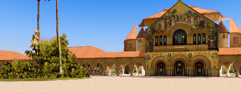
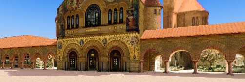
Google Earth has not gotten around to including these structures at Stanford yet. Why wait? Let the community do it. How do you get Parallel Graphics to play in the community spirit with Google? Will it happen sooner, later, or never?
Thursday, May 3, 2007
Why Support Your Virtual City?
There are many reasons to support a community effort to build a virtual city:
- Let's face it, the most visited urban centers know how to milk perception to attract masses to come and drop some bills. But what about community pride in sharing the unique history associated with a place where thousands gave their lives to participating (whether they cared about it or not). Virtual Tourism is a concept we all can take advantage of to tell our favorite stories about the place we live.
- A 3-D representative model of place with links, stories, and freedom to explore online is a natural way to help others do their Travel Planning and have it carry over to when they actually make it to visit in person.
- We shouldn't fool ourselves. Our town and city planners could use our opinions regarding the future use of our shared geography. What easier way to provide feedback than in the forum of a virtual city demonstrating potential changes we can respond to? Land Planning, Usage, and Urban Structures can all be facilitated through a well-publicized virtual city.
- It is not just the open spaces, commercial structures and residential structures that can benefit from shared visualization and exploration. Civil engineering projects, telecommunications, utilities, and other infrastructure takes up physical space, disrupts our daily activities, and makes itself visible for the long-run.
- Visualization of Weather and other environmental attributes help a community understand their relationship to nature as well as plan for spending time outdoors (something we are doing less and less to the degradation of our sense of community).
Wednesday, May 2, 2007
The Best Cure for Gravity
I don't know about you, but these days gravity seems to be pulling on me harder than ever. It's not that I've added any weight to my frame - quite the contrary. To make a true contribution in the open source coding realm seems harder and harder as people more qualified than myself take up the opportunities. That's probably one emotional burden that only seems to add to my sense of being pulled down to one spot. There are others. One way to overcome that feeling is to give into the successes of others and root on anyone who is making a contribution. Perhaps they are not aware of their journey as significant. Let them know it is (without adding undue pressure to their timelines).
Our virtual earth visualizations systems free us from gravity whenever we want to take advantage. Yesterday, I was going back and forth between a site in Boston and a site in Washington, DC and some pattern recognition component of my perceptive process came alive to tell me 'you've flown that route before'. Yes, indeed, it looked so familiar to flights I made often in 1985, looking for that first job opportunity. The only difference is I was flying at a higher altitude than where commercial airlines find stable air and a manageable oxygen supply. There are an enormous number of possible navigation strategies for us to enable in exploring our virtual cities. We can choose our perspective on gravity and lighten up our emotional stance towards a rather intense phenomenon that seems to give the birds their self-esteem. Gravity as the weakest force indeed.
consider a paper on 3-d navigation
GPS Enables Us All
I still haven't purchased my first Global Positioning System (GPS) unit. I imagine so many of my close calls hiking out in nature would have been avoided with either a compass or GPS unit. I remember fondly Dad and I emerging from the woods at 10:30pm under a full moon after losing track of where we were and hiking ten miles longer than we expected. Or, hiking south of the equator where I got confused, finally saw the sun setting on the wrong side of the sky, and extended an already ambitious 30 kilometer hike into a 46 kilometer hike (without seeing another human all day).
We get older and supposedly we get wiser. And, the devices keep getting cheaper and more reliable. Better yet, the devices enable this whole virtual earth, bottom up contribution process that is behind half the reasons we should build our community-managed virtual cities now. I haven't thought this through enough yet to eloquently convince you of my position, but as Bonnie DeVarco states in her article Earth as A Lens: Global Collaboration, GeoCommunication, and The Birth of EcoSentience:
Thanks Bonnie - that's a good place to start. Let's make virtual cities the focus of some of these new emergent organizations.
We get older and supposedly we get wiser. And, the devices keep getting cheaper and more reliable. Better yet, the devices enable this whole virtual earth, bottom up contribution process that is behind half the reasons we should build our community-managed virtual cities now. I haven't thought this through enough yet to eloquently convince you of my position, but as Bonnie DeVarco states in her article Earth as A Lens: Global Collaboration, GeoCommunication, and The Birth of EcoSentience:
Looking closer at current trends around the globe, it is becoming clear that the changing face of cell phones and the E-911 mandate will converge with this new experience of location-awareness, something that is already infusing our youth with a zeal for the experience of continuous geolocation. Due to the popularity of portable GPS units for travelers, bike riders, backpackers, and adventurers to chart their planetary journeys, new organizations and tools are arising. GPS devices are converging with software and game technology to create a new genre of GPS-enabled communication.
Thanks Bonnie - that's a good place to start. Let's make virtual cities the focus of some of these new emergent organizations.
Monday, April 30, 2007
Bottom Up Building Alive on Google Earth
I downloaded the Google Earth for Mac client and ramped it up on my MacBook Pro. Two words came to mind: shock and awe. The ability to go anywhere on Earth and drill down to street level in any town I had ever lived in, see the actual structure I lived in, and bring back a flood of memories of my geospatial existence connects neurons in a fascinating way. The other experience I can think of that rattles my neurons that dramatically for me is attending the symphony. I had better be careful because I can feel an addiction coming on.
The idea that anyone on the planet can be modeling any structure on the planet at any time and then uploading that structure into Google Earth is a siren call to be there indefinitely. The fact that the Mac community has access to the process from creation to visualization magnifies the feeling two or three-fold. Through opening up the process to Mac users, we attract a whole other culture to the possibilities of virtual cities. Now, if we can attract all the cultures of the world and evolve the platform to show historical context to our impact on the planet, we will have a very powerful shared story that can't help but bring us together by shared understanding and a sense of accomplishment. The impact of our joint actions will be expressed more tangibly.
Saturday, April 28, 2007
Dreams and Reality
The Digital Visualization Group at UNC-Charlotte does a nice job of capturing the technological needs of a Virtual Cities framework in their Virtual Geographic Information System project. Of course, we need access to all that data that makes a virtual city possible. The virtual terrain project does a nice job of capturing the essence of what I've been seeing within the sciences the last eight years:
The impediments to data openness can be summarized by the human failings that cause them: Greed, Ignorance, Short-sightedness, and Fear.
Greed - Greed can be a issue, especially in countries where quasi-governmental groups operate without public accountability. Instead of treating geodata as a public resource, it is hoarded by organizations that exists as monopolies, bilking the public again and again for data that the public has already paid for.
Ignorance and Short-sightedness - Many governments are largely oblivious to the benefits of a publicly available geospatial infrastructure. They are often stuck in modes of thinking that are decades or centuries out of date, with no awareness of their own country's geospatial industry, or the myriad benefits of open geodata for education, planning, and countless potential future uses.
Fear - In many countries, the government allows mapping to be controlled by the military, which often treats every single bit of geodata as a potential secret that must be kept from that country's enemies - every road, building, and tree! Since 2001/9/11, this attitude has also crept into parts of the US government, with a handful of datasets pulled from the public in the name of "fighting terrorism", although most of these fears have since been shown to be baseless. The vast majority of geodata is useless to "terrorists", while being of immense value to the public.
Thoughts to Ponder on Architecture
As of today, Wikipedia contains an entry on Christopher Alexander which states: 'Reasoning that users know more about the buildings they need than any architect could, Alexander produced and validated (in collaboration with Sarah Ishikawa and Murray Silverstein) a pattern language designed to empower any human being to design and build at any scale.'
Virtual cities give us all the opportunity to consider these design patterns across all structures within our community. As annotators of a virtual city, we all can index representative buildings in the virtual model and debate the design for our shared learning. As we all get smarter about design, we can get smarter about our shared community interests and promote the ideas we favor with those who design.
a site suggesting architectural design patterns
Thursday, April 26, 2007
Virtual City Central
I see there is already a solid virtual city reference out there called the Virtual Terrain Project. Nice job of collecting many useful links in one place and providing a clean, organized listing of them - even one of my favorite groups of all time, the Algorithmic Botany site at the University of Calgary. Hey, Mr. P (aka Przemyslaw Prusinkiewicz), thanks for being you. And, horray, water continues to be a competitive field for modelers to strut their stuff. And, a very nice comparison of different whole earth viewers that makes my limited words a few entries back obsolete.
a reminder: the vtp
Virtual Cities
OK, so creating video games is quite a popular pursuit. There are degrees for future designers, programmers, testers, reviewers, etc. Great promise for changing the way we learn. But, how do we push out a project to a community effort? Web 2.0 says the people have the power when it comes to content. I'm thinking the ultimate community project, just begging to be attempted, is the virtual city. Google Earth provides the globe for us to drop our city onto. Google provides a nice SketchUp application for beginners to quickly produce virtual buildings and other architectural structures. Could we get a whole town to quickly model all structures and have someone stitch it into a coherent whole? Certainly, the time has come, no? Twelve years have passed since the Virtual Reality Modeling Language suggested a road for us to follow in building virtual content. Planet 9 Studios has professionally built virtual cities (San Francisco and New York kicking them off). I think someone ought to attempt to get a city to model itself from the ground up, grass roots and all. Hopefully, my Virtual Cities page will promote the idea well enough to find interest out there. If we build it, they will come (right?).
A Degree in Video Game Development?
So what should a degree in video game development look like? Well, personally, I'd like it to look more like a simulation theory degree with more science and mathematics involved. Most of the associate degrees out there promote computer science skills that are more about understanding how computer languages and popular software interfaces work. As the RPI Web site mentions, 'Other institutions offering classes in video game studies include Princeton, Carnegie Mellon University, Massachusetts Institute of Technology, and the University of California at Irvine. There are also specialized schools, like DigiPen in Redmond, Washington, that teach nothing but game design'.
Seems to me courses on inputs (informatics and information theory), process (e.g. artificial intelligence, data assimilation, kinematics), and outputs (e.g. artistic rendering, data presentation, architecture) could expand to include a wealth of topics that have overlap with the general background education a liberal arts student would want to gain during undergraduate study. Seems using the computer as the center of course deliverables focus would be pretty interesting. We've been using paper as the focus for long enough. Just think more expansive on this theme of computer as learning delivery vehicle and then consider the potential of simulating those phenomena you learn in math and science (alongside the skills gained by requiring the deliverables be explained in clear wording) in order to prove to others you understand them. The degree then becomes more about creating an interactive cyberspace (hopefully with modular pieces) than creating a single video game using the popular methods of today.
keiser college: video game degree
Nine Years Later
Of course, yesterday I should have mentioned the heroic efforts of certain forebearers. The code bases whipped together to connect people worldwide in 3-D cyberspace were a blast to participate with. If only that same heroic effort could be applied to today's open source design patterns in our realm.
One seventh entry link:
digitalspace traveler: home page
Open Source Integration
After paying $19 a year to participate in a cyberspace building community experiment that took off in a nice critical-mass curve, I decided I'd wait for an open source graphics-engine to be incorporated into a platform I could help extend in a similar manner. Seems there is a common pattern out there for properly integrating other open source components into a scene-graph based graphics engine.
If only we could move ahead and get academic departments all over the world working on the same grand vision. We'd not only have a platform for connecting in cyberspace, we'd have a place to try out interesting algorithms, play interesting games, interact with interesting data, and do some important research as to how these cyberspace platforms could be used more effectively. Seems Rensselaer Polytechnic is building a video games major (I read it in the alumni magazine). Certainly part of such a degree should be spent developing the underlying environment on which games can be rolled out en masse. Who else is going to follow suit? How long is it going to take to get this going (and having the different students from different universities participate in one massive project?
Some sixth entry links:
activeworlds: home page
digital spaces: home page
ogre: home page
cegui: home page
openal: home page
Whole Earth Interfaces
After paying $79 for a whole earth interface application four years ago and forking over $49 a year later and $39 the year after that, I finally downloaded Google Earth for free and kicked my paying habit. Such a nice raging debate over whether the world will pay more attention to critical whole Earth system data sets now that they can map data visually to an interactive earth accessible over the Web.
The pale blue dot syndrome, as Carl Sagan calls it, comes to your home PC. Just look how vulnerable our sweet little planet looks floating out there all by its lonesome. Of course, the world disappears under the ocean on 2/3 of the surface. That's silly, eh? Ocean data sets will turn out to be the real important ones as they become more and more available. El Nino. La Nina. Driving forces that make winners and losers of communities on land. Thankfully, we have two competing products already. One starting with scientific data and the other with more recognizable data (aerial photography of city flyovers). How excellent they've covered all of Indiana! Now, if only you could launch other applications from these planetary starting points. Hmmmmmm. Now there's a lot of potential in *that*, for sure.
Some fifth entry links:
nasa world wind earth viewer
google earth: home page
microsoft's: attempt
Grid-Enablement Software
Three days in San Diego attending a Globus 4 Toolkit Tutorial and Workshop got me thinking more about the potential of grid commuting emerging on the scene sooner rather than later. Sure, I've run a few multi-participant sessions on the Access Grid to attend conferences or connect with lab collaborators, but I hadn't thought much about how a certificate-based access point might be my key to the all the worlds computers some day. We've been developing some SOAP-based Web services to connect disparate systems by binding to various programming languages. We've been using WSDL and WSDD to identify and deploy them. But, I hadn't thought through how every programming task on every computer in the world could be accessed through a unified front based on those specifications. Nor did I expect the Globus 4 Toolkit to be based on such underlying components.
No doubt sitting at command central of such a grid-enabled empire could be quite a rush. What a potential for visualization... virtual communities, virtual organizations, virtual identities, load balancing statistics, and job control procedures lighting up one step then the next. No wonder why so much of the workshop revolved around security methods for protecting one's assets while connecting them for others to use. Some fourth entry links:
globus 4 toolkit: news page
access grid: home page
soap primer: version 1.2
wsdl:web services description language
wsdd:web services deployment descriptor
Visualization Toolkits
After attending PyCon 2005, the Python Convention, I became convinced that the Python community was worthy of supporting, just as I had given my heart and soul to the VRML and Java 3D communities in years past. I realized that the VRML community was a little too .com bulge for me (one too many extravagant parties instead of putting energy into making VRML successful on the Web). I felt like I was part of a great Java 3D community, but I then realized it was because I had access to the first alpha release and was only one of fifteen or so people really kicking the tires on a mission-critical project. The community was small and very easy to work with. But, alas, the project manager at Sun wasn't too interested in the community or the casual home user. Java 3D was all about middleware for high-performance computers that would crunch polygon integration for visualization of millions of polygon data sets worth megabucks to Sun in potential revenues. Fair enough, but a lost opportunity. I see there is finally an organized community around Java 3D but I don't get that passionate feeling of making a difference on the Web through the use of it. Enter the Visualization Toolkit. Python-wrapped and ready to be driven by all the well used Web protocols. Time to dive in and see what that means regarding Web integration potential. Some second entry links:
vtk site: vtk
pycon 2005 site: pycon talks
web 3D site: vrml`s evolution
java 3D community site: java.net
So this is blogging?
After setting up blogware twice before, I finally decided to bite the bullet, get myself my own domain, and set up the blog link off the home page front and center. I'll be blogging about things that are related to my dissertation such as the process and utility of generating scientific visualizations for consumption on the Web. Supposedly, up to seventy-some percent of brain activity is focused on processing the photons of light that enter our eyes. Seems there is an opportunity to make that a better experience than staring at a blank wall or reading the same forty or so keyboard characters over and over and over. Not that reading isn't the coolest opportunity afforded our brains since we get to invent our own imagery to connect to the words we read, but there is an opportunity to investigate certain phenomena more literally through our visual cortex and hopefully inspire us with experiences we aren't apt to run into in our daily existence. Photography is wonderful and I am sure some blog entries will be about a cool photo I've come across on the Web. But, I am more interested in seeing stuff that is abstract and yet inspired by nature. Supposedly, we need tools to help us experience those beauties. Visualization toolkits, for example. I hope to tie together some thoughts I've been having in a way that others might just want to follow along. Hence the blog. Some first entry links:
a daily: Earth Science Picture of the Day
another daily: Astronomy Picture of the Day
a book: Mapping the Next Millenium
Subscribe to:
Posts (Atom)